SHOP BY YEAR :: FOR OFFICE :: FOR CLASSROOM :: GIFT IDEAS :: CUSTOMER SERVICE

World Map 1941
Issue: December 1941
More Views
Enlarge Image
ZoomClick here to zoom!
Purchase Product :
Please select map format:
Laminated   
42" x 22.5" - $59.95
Laminated-w/Plastic Rails  (What are rails?)
42" x 22.5" - $76.95
Paper
42" x 22.5" - $49.95
Wallzilla Adhesive Format
42" x 22.5" - $89.95
Product Highlights
World Map 1941
Item#: X NGC 121941

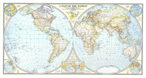
The Classic National Geographic World map of 1941. One of the last maps published prior to the bombing of Pearl Harbor, this extaordinary map shows the Eastern and Western Hemispheres, and features classic colorization to show the country borders and relief shading. A perfect complement to any world map collection.

The 1941 World map features:
• The Eastern and Western Hemispheres, beautifully created with the Azimuthal Equal-Area Projection
• Classic colorization to depict country borders in force in 1941
• Thousands of place names, including country capitals
• Insets for the "Land" and "Water" Hemispheres, showing elevation and ocean depths
• Insets showing population density for the Eastern and Western Hemispheres

Coverage Area: The World, North America, South America, Africa, Asia, Australia, Europe, Oceania, Antarctica

More Product Details

This map requires 7 business days to print and laminate prior to shipping.

Appearing in the December 1941 issue of the National Geographic Magazine, this World map has been reproduced from its original cartography in order to bring to life a beautiful poster previously only seen in National Geographic Magazine. This reproduction holds true to the high standards that National Geographic Maps are known for.

Perfect for home, office or classroom, this map also makes a great gift. Map collectors will surely want to add this map to their library.

The Paper version is printed on high quaility semi-gloss paper, perfect for framing.

The Laminated version uses 3mm laminate on both sides for durability, is easy to clean and markable.

From the National Geographic Classic Maps collection, this reproduction is just one of hundreds of titles available here. These maps are Printed on Demand. Sizes are approximate and may vary due to the nature of the trimming and laminating processes.
Shipping Conditions
Maps.com ships to Dometic US only

US FlagThis product can only be shipped to the Domestic U.S.A. (No APO's or PO Boxes)
TimeThis map requires 2 business days to print and laminate prior to shipping.