SHOP BY YEAR :: FOR OFFICE :: FOR CLASSROOM :: GIFT IDEAS :: CUSTOMER SERVICE

Above The Rockies Map 1995
Issue: July 1995
More Views
Enlarge Image
ZoomClick here to zoom!
Purchase Product :
Please select map format:
Laminated   
20" x 31" - $39.95
Laminated-w/Plastic Rails  (What are rails?)
20" x 31" - $51.95
Paper
20" x 31" - $29.95
Wallzilla Adhesive Format
20" x 31" - $59.95
Product Highlights
Above The Rockies Map 1995
Item#: X NGC 071995b

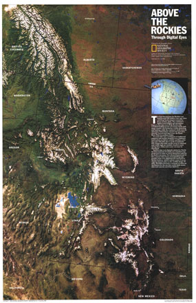
NOAA satellite imaging formed the basis of this fascinating map of the Rocky Mountain region which was then computer-enhanced by WorldSat International of Canada. Published in July 1995, this map is a perfect companion to the Heart of the Rockies map published in the same issue.

The 1995 Above the Rockies map features:
• A digitally-enhanced satellite image of the region
• State boundaries and major cities
• Information about the making of this map

Coverage Area: The Rocky Mountains of Arizona, New Mexico, Utah, Colorado, Wyoming, Idaho, Montana, Alberta, and British Columbia

More Product Details

This map requires 7 business days to print and laminate prior to shipping.

Appearing in the July 1995 issue of the National Geographic Magazine, this Above The Rockies map has been reproduced from its original cartography in order to bring to life a beautiful poster previously only seen in National Geographic Magazine. This reproduction holds true to the high standards that National Geographic Maps are known for.

Perfect for home, office or classroom, this map also makes a great gift. Map collectors will surely want to add this map to their library.

The Paper version is printed on high quaility semi-gloss paper, perfect for framing.

The Laminated version uses 3mm laminate on both sides for durability, is easy to clean and markable.

From the National Geographic Classic Maps collection, this reproduction is just one of hundreds of titles available here. These maps are Printed on Demand. Sizes are approximate and may vary due to the nature of the trimming and laminating processes.
Shipping Conditions
Maps.com ships to Dometic US only

US FlagThis product can only be shipped to the Domestic U.S.A. (No APO's or PO Boxes)
TimeThis map requires 2 business days to print and laminate prior to shipping.