SHOP BY YEAR :: FOR OFFICE :: FOR CLASSROOM :: GIFT IDEAS :: CUSTOMER SERVICE

Mid Atlantic States Map 1976
Issue: October 1976
More Views
Enlarge Image
ZoomClick here to zoom!
Purchase Product :
Please select map format:
Laminated   
35" x 22.5" - $39.95
Laminated-w/Plastic Rails  (What are rails?)
35" x 22.5" - $51.95
Paper
35" x 22.5" - $29.95
Wallzilla Adhesive Format
35" x 22.5" - $59.95
Product Highlights
Mid Atlantic States Map 1976
Item#: X NGC 101976a

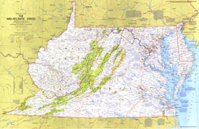
Explore the earliest English settlements in North America, Revolutionary War and Civil War sites, and the nation's capital in the Mid-Atlantic States map. Published in October 1976 as part of the "Close-up: U.S.A." series, this map is half of a two-map set. It appeared with its companion map, "Maryland, Virginia, Delaware, West Virginia: Beckoning Land Beside Bay and Sea" and two articles on the Potomac River.

The 1976 The Mid-Atlantic States map features:
• Sites and events noted in many tourist destinations as well as historical notes
• National parks, state parks, wildlife refuges, national and state forests, Indian reservations, ski areas, and more
• Wild or scenic rivers, intracoastal waterways, and recreational trails
• Capitals, cities, and towns
• Interstate highways, other roads, passenger railroads, canals, and airports
• Subtle mountain relief, rivers, lakes, and swamps

Coverage Area: Maryland, Delaware, District of Columbia, Virginia, West Virginia

More Product Details

This map requires 7 business days to print and laminate prior to shipping.

Appearing in the October 1976 issue of the National Geographic Magazine, this Mid Atlantic States map has been reproduced from its original cartography in order to bring to life a beautiful poster previously only seen in National Geographic Magazine. This reproduction holds true to the high standards that National Geographic Maps are known for.

Perfect for home, office or classroom, this map also makes a great gift. Map collectors will surely want to add this map to their library.

The Paper version is printed on high quaility semi-gloss paper, perfect for framing.

The Laminated version uses 3mm laminate on both sides for durability, is easy to clean and markable.

From the National Geographic Classic Maps collection, this reproduction is just one of hundreds of titles available here. These maps are Printed on Demand. Sizes are approximate and may vary due to the nature of the trimming and laminating processes.
Shipping Conditions
Maps.com ships to Dometic US only

US FlagThis product can only be shipped to the Domestic U.S.A. (No APO's or PO Boxes)
TimeThis map requires 2 business days to print and laminate prior to shipping.