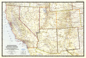
The Southwestern United States map was published in December 1948. Of particular note on this map is the absence of Lake Powell and the Glen Canyon Dam. Construction did not begin on the controversial dam until 1956. The 1948 Southwestern United States map features:
• State capitals, cities, and towns
• Principal railways, U.S. highways, and state highways
• Mountains, major rivers, and major lakes
• Subtle mountain relief
• Elevations in feet
• Geographical equivalents and abbreviations
Coverage Area: California, Nevada, Utah, Arizona, New Mexico, Colorado
|


 Click here to zoom!
