SHOP BY YEAR :: FOR OFFICE :: FOR CLASSROOM :: GIFT IDEAS :: CUSTOMER SERVICE

Japan Map 1944 with Asia and the Pacific Ocean
Issue: April 1944
More Views
Enlarge Image
ZoomClick here to zoom!
Purchase Product :
Please select map format:
Laminated   
27" x 35" - $39.95
Laminated-w/Plastic Rails  (What are rails?)
27" x 35" - $51.95
Paper
27" x 35" - $29.95
Wallzilla Adhesive Format
27" x 35" - $59.95
Product Highlights
Japan Map 1944 with Asia and the Pacific Ocean
Item#: X NGC 041944

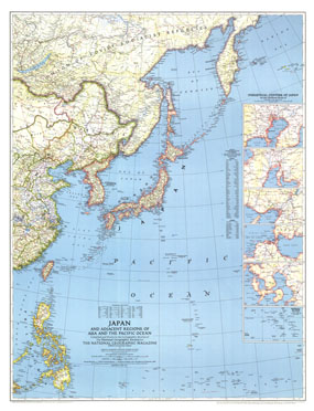
Published in April 1944 during World War II, this striking map of Japan and the adjacent regions of Asia and the Pacific Ocean accompanied an article entitled "Japan and the Pacific." Particular detail is paid to the industrial centers of Japan which appear in detailed insets.

The 1944 Japan map with adjacent regions of Asia and the Pacific Ocean features:
• Inset maps of the industrial centers of Japan
• Marshall Islands inset
• Beautifully colored borders
• Principal highways, railroads, and dismantled railroads
• Thousands of place names including cities and towns
• Rivers and lakes

Coverage Area: Japan, Taiwan, Chosen (Korea), Manchuria, Philippines

More Product Details

This map requires 7 business days to print and laminate prior to shipping.

Appearing in the April 1944 issue of the National Geographic Magazine, this Japan map with adjacent regions of Asia and the Pacific Ocean has been reproduced from its original cartography in order to bring to life a beautiful poster previously only seen in National Geographic Magazine. This reproduction holds true to the high standards that National Geographic Maps are known for.

Perfect for home, office or classroom, this map also makes a great gift. Map collectors will surely want to add this map to their library.

The Paper version is printed on high quaility semi-gloss paper, perfect for framing.

The Laminated version uses 3mm laminate on both sides for durability, is easy to clean and markable.

From the National Geographic Classic Maps collection, this reproduction is just one of hundreds of titles available here. These maps are Printed on Demand. Sizes are approximate and may vary due to the nature of the trimming and laminating processes.
Shipping Conditions
Maps.com ships to Dometic US only

US FlagThis product can only be shipped to the Domestic U.S.A. (No APO's or PO Boxes)
TimeThis map requires 2 business days to print and laminate prior to shipping.