 |
|
|
|
|
Mount Everest Map 1988
Issue: November 1988
|
|
|
|
|
|
|
| Product Highlights |
| Mount Everest Map 1988 |
| Item#: X NGC 111988b |
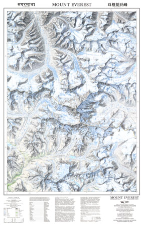
This beautiful map of Mount Everest and the surrounding region was published in November 1988 with three articles on Mount Everest including "Roof of the World." Featuring soft, colored shading and technical information about the making of the map, this work is a wonderful companion to the computer-generated map of the Himalayas which appeared in the same issue. The 1988 Mount Everest map features:
• Geographical features including lakes, rivers, crevasses, rocks, forests, and more
• Trails, ruins, and stone walls and houses
• International boundary
• Glossary of Chinese, Tibetan, and Nepali terms
• Geographical equivalents
• Contributors and technical data
Coverage Area: Mount Everest
|
|
 |
More Product Details
This map requires 7 business days to print and laminate prior to shipping.
Appearing in the November 1988 issue of the National Geographic Magazine, this Mount Everest map has been reproduced from its original cartography in order to bring to life a beautiful poster previously only seen in National Geographic Magazine. This reproduction holds true to the high standards that National Geographic Maps are known for.
Perfect for home, office or classroom, this map also makes a great gift. Map collectors will surely want to add this map to their library.
The Paper version is printed on high quaility semi-gloss paper, perfect for framing.
The Laminated version uses 3mm laminate on both sides for durability, is easy to clean and markable.
From the National Geographic Classic Maps collection, this reproduction is just one of hundreds of titles available here. These maps are Printed on Demand. Sizes are approximate and may vary due to the nature of the trimming and laminating processes.
|
|
Shipping Conditions
Maps.com ships to Dometic US only
 | This product can only be shipped to the Domestic U.S.A. (No APO's or PO Boxes) |  | This map requires 2 business days to print and laminate prior to shipping. |
|
|
|
|


 Click here to zoom!