SHOP BY YEAR :: FOR OFFICE :: FOR CLASSROOM :: GIFT IDEAS :: CUSTOMER SERVICE

The Balkans Map 1962
Issue: February 1962
More Views
Enlarge Image
ZoomClick here to zoom!
Purchase Product :
Please select map format:
Laminated   
25" x 19" - $19.95
Laminated-w/Plastic Rails  (What are rails?)
25" x 19" - $29.95
Paper
25" x 19" - $14.95
Wallzilla Adhesive Format
25" x 19" - $34.95
Product Highlights
The Balkans Map 1962
Item#: X NGC 021962

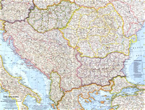
Published in February 1962 with the article "Yugoslavia's Window on the Adriatic," this map of the Balkans shows Yugoslavia a year before its name was changed to the Socialist Federal Republic of Yugoslavia. A strong border design separates communist from non-communist countries on this map.

The 1962 Balkans map features:
• Counties of Hungary with their capitals
• Notes about the provinces of Yugoslavia and Bulgaria
• A specific boundary showing the division between communist and non-communist countries
• Capitals, cities, and towns
• Superhighways, roads, railroads, canals, and places with scheduled air service
• Mountains, passes, rivers, lakes, and glaciers
• Oil fields and pipelines

Coverage Area: Yugoslavia, Hungary, Romania, Bulgaria, Albania, Austria, northern Greece, northern Turkey

More Product Details

This map requires 7 business days to print and laminate prior to shipping.

Appearing in the February 1962 issue of the National Geographic Magazine, this The Balkans map has been reproduced from its original cartography in order to bring to life a beautiful poster previously only seen in National Geographic Magazine. This reproduction holds true to the high standards that National Geographic Maps are known for.

Perfect for home, office or classroom, this map also makes a great gift. Map collectors will surely want to add this map to their library.

The Paper version is printed on high quaility semi-gloss paper, perfect for framing.

The Laminated version uses 3mm laminate on both sides for durability, is easy to clean and markable.

From the National Geographic Classic Maps collection, this reproduction is just one of hundreds of titles available here. These maps are Printed on Demand. Sizes are approximate and may vary due to the nature of the trimming and laminating processes.
Shipping Conditions
Maps.com ships to Dometic US only

US FlagThis product can only be shipped to the Domestic U.S.A. (No APO's or PO Boxes)
TimeThis map requires 2 business days to print and laminate prior to shipping.