 |
|
|
|
|
Travelers Map Of The British Isles Map 1974 Side 1
Issue: April 1974
|
|
|
|
|
|
|
| Product Highlights |
| Travelers Map Of The British Isles Map 1974 Side 1 |
| Item#: X NGC 041974a |
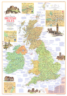
Half of a two-map set, this map of the British Isles contains an abundance of information on a variety of tourist sites and activities. Published in April 1974 with the article "The England of Charles Dickens," this map is a must-have for those traveling to the United Kingdom or Ireland. The 1974 Traveler's Map of the British Isles side 1 features:
• National parks of England and Wales
• Inset maps of Dublin, Edinburgh, London, and Stratford-upon-Avon
• Superhighways, roads, railroads, and airports
• Cathedrals, abbeys, churches, and priories
• Castles, mansions, palaces, battles, ruins, and other places of interest
• Information on an abundance of events, sites of interest, and tourist activities
• Historical information about popular tourist destinations
Coverage Area: British Isles
|
|
 |
More Product Details
This map requires 7 business days to print and laminate prior to shipping.
Appearing in the April 1974 issue of the National Geographic Magazine, this Travelers Map Of The British Isles map has been reproduced from its original cartography in order to bring to life a beautiful poster previously only seen in National Geographic Magazine. This reproduction holds true to the high standards that National Geographic Maps are known for.
Perfect for home, office or classroom, this map also makes a great gift. Map collectors will surely want to add this map to their library.
The Paper version is printed on high quaility semi-gloss paper, perfect for framing.
The Laminated version uses 3mm laminate on both sides for durability, is easy to clean and markable.
From the National Geographic Classic Maps collection, this reproduction is just one of hundreds of titles available here. These maps are Printed on Demand. Sizes are approximate and may vary due to the nature of the trimming and laminating processes.
|
|
Shipping Conditions
Maps.com ships to Dometic US only
 | This product can only be shipped to the Domestic U.S.A. (No APO's or PO Boxes) |  | This map requires 2 business days to print and laminate prior to shipping. |
|
|
|
|


 Click here to zoom!