 |
|
|
|
|
Europe Map 1957
Issue: June 1957
|
|
|
|
|
|
|
| Product Highlights |
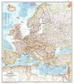
| Europe Map 1957 |
| Item#: X NGC 061957 |
National Geographic published this map of Europe during the the Cold War in June 1957 with an article entitled "Through Europe by Trailer Caravan." A compelling historical piece, an inset shows which countries were Communist at the time. The 1957 Europe map features:
• Inset illustrating Communist and Non-Communist countries
• Thousands of place names including capitals, cities, and towns
• Railroads (both existing and under construction), roads, Berlin corridor, routes, principal airports, and canals
• Ocean bathymetry
• Moutain, lakes, and rivers
• Water holes, passes, and ruins
• Oil fields and oil pipelines
Coverage Area: Europe, western Turkey, western USSR
|
|
 |
More Product Details
This map requires 7 business days to print and laminate prior to shipping.
Appearing in the June 1957 issue of the National Geographic Magazine, this Europe map has been reproduced from its original cartography in order to bring to life a beautiful poster previously only seen in National Geographic Magazine. This reproduction holds true to the high standards that National Geographic Maps are known for.
Perfect for home, office or classroom, this map also makes a great gift. Map collectors will surely want to add this map to their library.
The Paper version is printed on high quaility semi-gloss paper, perfect for framing.
The Laminated version uses 3mm laminate on both sides for durability, is easy to clean and markable.
From the National Geographic Classic Maps collection, this reproduction is just one of hundreds of titles available here. These maps are Printed on Demand. Sizes are approximate and may vary due to the nature of the trimming and laminating processes.
|
|
Shipping Conditions
Maps.com ships to Dometic US only
 | This product can only be shipped to the Domestic U.S.A. (No APO's or PO Boxes) |  | This map requires 2 business days to print and laminate prior to shipping. |
|
|
|
|


 Click here to zoom!