SHOP BY YEAR :: FOR OFFICE :: FOR CLASSROOM :: GIFT IDEAS :: CUSTOMER SERVICE

Germany And Its Approaches Map 1938-39
Issue: July 1944
More Views
Enlarge Image
ZoomClick here to zoom!
Purchase Product :
Please select map format:
Laminated   
33.5" x 26" - $39.95
Laminated-w/Plastic Rails  (What are rails?)
33.5" x 26" - $51.95
Paper
33.5" x 26" - $29.95
Wallzilla Adhesive Format
33.5" x 26" - $59.95
Product Highlights
Germany And Its Approaches Map 1938-39
Item#: X NGC 071944

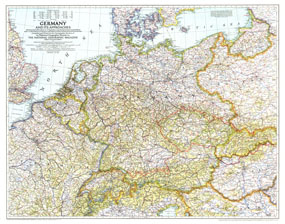
A must-have for those interested in World War II, this informative map was published in July 1944 with an article entitled "Landing Craft for Invasion." This work shows the international boundaries as of Sept. 1, 1939, the day Germany invaded Poland, and boundaries as of Jan. 1, 1938, before Germany seized Austria and Czechoslovakia.

The Germany and Its Approaches, 1938-39 map features:
• International boundaries shown as they existed the day Germany invaded Poland, and also before Germany seized Austria and Czechoslovakia
• Thousands of place names including capitals, cities, and towns
• Highways, superhighways, railroads, and canals
• Geographical features including mountains, rivers, lakes, and mountain passes
• Geographical Equivalents and abbreviations

Coverage Area: Germany, eastern France, Switzerland, Austria, Czechoslovakia, Hungary, Poland, east Prussia, southern Denmark

More Product Details

This map requires 7 business days to print and laminate prior to shipping.

Appearing in the July 1944 issue of the National Geographic Magazine, this Germany And Its Approaches, 1938-39 map has been reproduced from its original cartography in order to bring to life a beautiful poster previously only seen in National Geographic Magazine. This reproduction holds true to the high standards that National Geographic Maps are known for.

Perfect for home, office or classroom, this map also makes a great gift. Map collectors will surely want to add this map to their library.

The Paper version is printed on high quaility semi-gloss paper, perfect for framing.

The Laminated version uses 3mm laminate on both sides for durability, is easy to clean and markable.

From the National Geographic Classic Maps collection, this reproduction is just one of hundreds of titles available here. These maps are Printed on Demand. Sizes are approximate and may vary due to the nature of the trimming and laminating processes.
Shipping Conditions
Maps.com ships to Dometic US only

US FlagThis product can only be shipped to the Domestic U.S.A. (No APO's or PO Boxes)
TimeThis map requires 2 business days to print and laminate prior to shipping.