 |
|
|
|
|
British Isles Map 1979
Issue: October 1979
|
|
|
|
|
|
|
| Product Highlights |
| British Isles Map 1979 |
| Item#: X NGC 101979a |
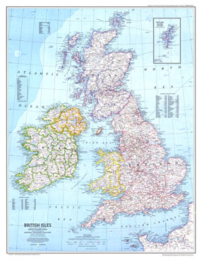
This attractive map of the British Isles, published in October of 1979, accompanied the map of Medieval England in the same issue. In addition to places of interest such as ruins and battle sites, this map also includes ferry routes. The 1979 British Isles map features
• Inset of the Shetland Islands
• Regions of Scotland, districts of Northern Ireland, counties of Ireland, and counties of England and Wales
• Capitals, cities, and towns
• Superhighways, railroads, roads, canals, and airports
• Ferry routes
• Ruins, sites, and battle sites
• Oil fields and pipelines
Coverage Area: British Isles
|
|
 |
More Product Details
This map requires 7 business days to print and laminate prior to shipping.
Appearing in the October 1979 issue of the National Geographic Magazine, this British Isles map has been reproduced from its original cartography in order to bring to life a beautiful poster previously only seen in National Geographic Magazine. This reproduction holds true to the high standards that National Geographic Maps are known for.
Perfect for home, office or classroom, this map also makes a great gift. Map collectors will surely want to add this map to their library.
The Paper version is printed on high quaility semi-gloss paper, perfect for framing.
The Laminated version uses 3mm laminate on both sides for durability, is easy to clean and markable.
From the National Geographic Classic Maps collection, this reproduction is just one of hundreds of titles available here. These maps are Printed on Demand. Sizes are approximate and may vary due to the nature of the trimming and laminating processes.
|
|
Shipping Conditions
Maps.com ships to Dometic US only
 | This product can only be shipped to the Domestic U.S.A. (No APO's or PO Boxes) |  | This map requires 2 business days to print and laminate prior to shipping. |
|
|
|
|


 Click here to zoom!