SHOP BY YEAR :: FOR OFFICE :: FOR CLASSROOM :: GIFT IDEAS :: CUSTOMER SERVICE

Travelers Map Of Spain And Portugal Map 1984 Side 2
Issue: October 1984
More Views
Enlarge Image
ZoomClick here to zoom!
Purchase Product :
Please select map format:
Laminated   
22.5" x 36" - $39.95
Laminated-w/Plastic Rails  (What are rails?)
22.5" x 36" - $51.95
Paper
22.5" x 36" - $29.95
Wallzilla Adhesive Format
22.5" x 36" - $59.95
Product Highlights
Travelers Map Of Spain And Portugal Map 1984 Side 2
Item#: X NGC 101984b

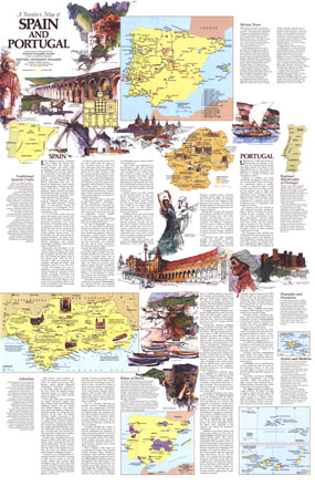
Published in October 1984, this half of the two-map set entitled A Traveler's Map of Spain and Portugal contains a wealth of information on the history and culture of the region. This map contains tour routes, a map of the Iberian wine country, information about the handicrafts of Spain and Portugal, and more.

The 1984 Traveler's Map of Spain and Portugal map side 2 features:
• Historical information about Spain and Portugal
• Inset maps of the Azores, the Madeira Islands, and the Canary Islands
• Information on Iberian tours complete with map and tour routes
• Maps and information on Andalusia and New Castile
• Facts about Iberian wines and a map showing official wine-producing regions
• Information on pousadas and paradores, regional handicrafts of Portugal, and traditional Spanish crafts
• Illustrations of historical and cultural sites

Coverage Area: Spain, Portugal

More Product Details

This map requires 7 business days to print and laminate prior to shipping.

Appearing in the October 1984 issue of the National Geographic Magazine, this Travelers Map Of Spain And Portugal map has been reproduced from its original cartography in order to bring to life a beautiful poster previously only seen in National Geographic Magazine. This reproduction holds true to the high standards that National Geographic Maps are known for.

Perfect for home, office or classroom, this map also makes a great gift. Map collectors will surely want to add this map to their library.

The Paper version is printed on high quaility semi-gloss paper, perfect for framing.

The Laminated version uses 3mm laminate on both sides for durability, is easy to clean and markable.

From the National Geographic Classic Maps collection, this reproduction is just one of hundreds of titles available here. These maps are Printed on Demand. Sizes are approximate and may vary due to the nature of the trimming and laminating processes.
Shipping Conditions
Maps.com ships to Dometic US only

US FlagThis product can only be shipped to the Domestic U.S.A. (No APO's or PO Boxes)
TimeThis map requires 2 business days to print and laminate prior to shipping.