SHOP BY YEAR :: FOR OFFICE :: FOR CLASSROOM :: GIFT IDEAS :: CUSTOMER SERVICE

Western Europe Map 1950
Issue: December 1950
More Views
Enlarge Image
ZoomClick here to zoom!
Purchase Product :
Please select map format:
Laminated   
30" x 38" - $59.95
Laminated-w/Plastic Rails  (What are rails?)
30" x 38" - $76.95
Paper
30" x 38" - $49.95
Wallzilla Adhesive Format
30" x 38" - $89.95
Product Highlights
Western Europe Map 1950
Item#: X NGC 121950

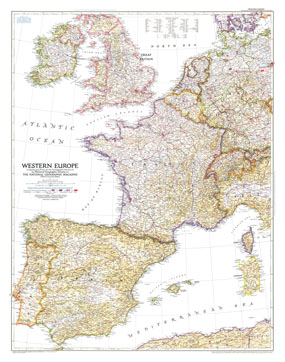
Published in December 1950, the Western Europe map is a snapshot of the region as it stood shortly after the end of the Second World War. The status of the Saar and the minor adjustments in Germany's boundary with the Netherlands, Belgium, Luxembourg, and France are provisional at the time, pending a treaty of peace with Germany.

The 1950 Western Europe map features:
• Notes about post-World War II borders
• American, British, French, and Russian occupation zones in Germany shown
• Capitals, cities, and towns
• Highways, Autobahn, principal railways, canals, and principal airports
• Mountains, passes, rivers, lakes, and glaciers
• Geographical equivalents
• Ruins

Coverage Area: Ireland, Great Britain, Portugal, Spain, France, Belgium, Luxembourg, Netherlands, Switzerland, southern Denmark, western Germany, northwestern Italy

More Product Details

This map requires 7 business days to print and laminate prior to shipping.

Appearing in the December 1950 issue of the National Geographic Magazine, this Western Europe map has been reproduced from its original cartography in order to bring to life a beautiful poster previously only seen in National Geographic Magazine. This reproduction holds true to the high standards that National Geographic Maps are known for.

Perfect for home, office or classroom, this map also makes a great gift. Map collectors will surely want to add this map to their library.

The Paper version is printed on high quaility semi-gloss paper, perfect for framing.

The Laminated version uses 3mm laminate on both sides for durability, is easy to clean and markable.

From the National Geographic Classic Maps collection, this reproduction is just one of hundreds of titles available here. These maps are Printed on Demand. Sizes are approximate and may vary due to the nature of the trimming and laminating processes.
Shipping Conditions
Maps.com ships to Dometic US only

US FlagThis product can only be shipped to the Domestic U.S.A. (No APO's or PO Boxes)
TimeThis map requires 2 business days to print and laminate prior to shipping.