 |
|
|
|
|
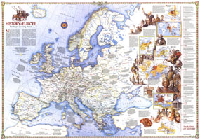
History Of Europe, The Major Turning Points Map 1983
Issue: December 1983
|
|
|
|
|
|
|
| Product Highlights |
| History Of Europe, The Major Turning Points Map 1983 |
| Item#: X NGC 121983a |
Travel through time with this brilliant supplement to the 1983 Europe map. An exploration of the major turning points in the history of Europe, this map also accompanied four articles in the December 1983 issue of National Geographic including "Rome of the East." Dazzling illustrations and multiple inset maps make this a must-have for any student of European history. The 1983 "History of Europe, the major turning points" map features:
• Tapestry of History illustrated timeline from 4500 B.C.-A.D. 1979
• Maps of Europe in 814 and the Roman Empire, ca. 400
• Insets of The World in 1500, the Growth of Prussia, and the Congress of Vienna in 1815
• Inset map of European Imperialism, 1914
• Map of Europe during World War II, 1939-1942
• Major European cities, as well as towns with 15th century printing presses, Universtities before the 16th century, cathedrals, battlefields, archaeological sites, medieval roads, canals circa 1750, and historical trade routes
• Facts about major turning points in European history as well as dazzling illustrations of historical figures
Coverage Area: Europe, western Soviet Union
|
|
 |
More Product Details
This map requires 7 business days to print and laminate prior to shipping.
Appearing in the December 1983 issue of the National Geographic Magazine, this History Of Europe, The Major Turning Points map has been reproduced from its original cartography in order to bring to life a beautiful poster previously only seen in National Geographic Magazine. This reproduction holds true to the high standards that National Geographic Maps are known for.
Perfect for home, office or classroom, this map also makes a great gift. Map collectors will surely want to add this map to their library.
The Paper version is printed on high quaility semi-gloss paper, perfect for framing.
The Laminated version uses 3mm laminate on both sides for durability, is easy to clean and markable.
From the National Geographic Classic Maps collection, this reproduction is just one of hundreds of titles available here. These maps are Printed on Demand. Sizes are approximate and may vary due to the nature of the trimming and laminating processes.
|
|
Shipping Conditions
Maps.com ships to Dometic US only
 | This product can only be shipped to the Domestic U.S.A. (No APO's or PO Boxes) |  | This map requires 2 business days to print and laminate prior to shipping. |
|
|
|
|


 Click here to zoom!