 |
|
|
|
|
National Geographic Britain and Ireland Wall Map
Issue:
|
|
|
|
|
|
|
| Product Highlights |
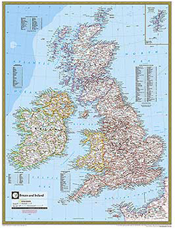
| National Geographic Britain and Ireland Wall Map |
| Item#: X NGA BRITIRE |
This detailed wall map of Britain and Ireland by National Geographic provides incredible detail for Ireland, Wales, England, and Scotland including ferry routes. Also contains an inset of the Shetland Islands.
Details featured on this Britain and Ireland Wall Map include:
• Political Boundaries
• Major Cities and Capitals
• Physical Terrain Shading
• Mountain Ranges, Highest Point
• Lakes, Rivers and Waterways
• Latitude and Longitude Lines
• Basic Bathymetry (Ocean Depths)
• Major Airports
• National Parks
|
|
 |
More Product Details
From the Print on Demand collection, this map requires 7 business days to print and laminate prior to shipping. Sizes are approximate and may vary due to the nature of the trimming and laminating processes.
This stunning, large-format print from the award-winning National Geographic World Atlas is informative with excellent attention to detail, clarity, color and accuracy, making it perfect for home, office, or school. This collection of wall maps includes Oceans, Continents, Countries, USA Regions and International Regions available in both Political and Physical detail.
|
|
Shipping Conditions
Maps.com ships to Dometic US only
 | This product can only be shipped to the Domestic U.S.A. (No APO's or PO Boxes) |  | This map requires 2 business days to print and laminate prior to shipping. |
|
|
|
|


 Click here to zoom!