 |
|
|
|
|
Jerusalem Map 1996
Issue: April 1996
|
|
|
|
|
|
|
| Product Highlights |
| Jerusalem Map 1996 |
| Item#: X NGC 041996a |
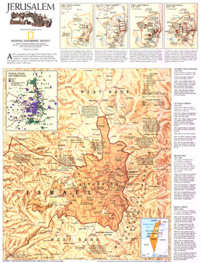
This thorough portrait of Jerusalem contains a brief history of the city, a historical timeline, maps of the various periods, and a modern look at this enigmatic holy place. Published in April 1996, this map accompanied "Jerusalem: The Old City" map and the article "The Three Faces of Jerusalem." The 1996 Jerusalem map features:
• Four historical maps of the city showing it in the First Temple, Second Temple, Early Arab, and Crusader periods
• Inset map showing population distribution of Arabs and Jews
• Historical timeline
• Israel-Jordan armistice line, 1949-1967
• Jerusalem city limits, Jewish settlements, refugee camps, ruins, and sites
• Divided highways and roads
• A location map
Coverage Area: Jerusalem
|
|
 |
More Product Details
This map requires 7 business days to print and laminate prior to shipping.
Appearing in the April 1996 issue of the National Geographic Magazine, this Jerusalem map has been reproduced from its original cartography in order to bring to life a beautiful poster previously only seen in National Geographic Magazine. This reproduction holds true to the high standards that National Geographic Maps are known for.
Perfect for home, office or classroom, this map also makes a great gift. Map collectors will surely want to add this map to their library.
The Paper version is printed on high quaility semi-gloss paper, perfect for framing.
The Laminated version uses 3mm laminate on both sides for durability, is easy to clean and markable.
From the National Geographic Classic Maps collection, this reproduction is just one of hundreds of titles available here. These maps are Printed on Demand. Sizes are approximate and may vary due to the nature of the trimming and laminating processes.
|
|
Shipping Conditions
Maps.com ships to Dometic US only
 | This product can only be shipped to the Domestic U.S.A. (No APO's or PO Boxes) |  | This map requires 2 business days to print and laminate prior to shipping. |
|
|
|
|


 Click here to zoom!