SHOP BY YEAR :: FOR OFFICE :: FOR CLASSROOM :: GIFT IDEAS :: CUSTOMER SERVICE

Travels Of George Washington Map 1932
Issue: January 1932
More Views
Enlarge Image
ZoomClick here to zoom!
Purchase Product :
Please select map format:
Laminated   
20" x 30" - $19.95
Laminated-w/Plastic Rails  (What are rails?)
20" x 30" - $29.95
Paper
20" x 30" - $14.95
Wallzilla Adhesive Format
20" x 30" - $34.95
Product Highlights
Travels Of George Washington Map 1932
Item#: X NGC 011932

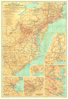
The map of the Travels of George Washington was published in January 1932 in cooperation with the United States Commission for the Celebration of the Two Hundredth Anniversary of the Birth of George Washington. Inset maps of major colonial cities including Boston, New York, and Philadelphia as well as Washington's Mount Vernon home and the Tidewater Virginia area add great detail to this unique historic map.

The 1932 Travels of George Washington map features:
• Inset maps of Boston, New York and the Lower Hudson, Philadelphia, and Tidewater Virginia
• A map of Mount Vernon, Washington's home
• Places visited by Washington lettered in red
• Red Roman numerals used to indicate routes and the period of Washington's life in which the travel occurred
• Colonial highways
• Lettering of place names indicating the places existing in Washington's time and those places built or renamed since

Coverage Area: Northeastern United States

More Product Details

This map requires 7 business days to print and laminate prior to shipping.

Appearing in the January 1932 issue of the National Geographic Magazine, this Travels Of George Washington map has been reproduced from its original cartography in order to bring to life a beautiful poster previously only seen in National Geographic Magazine. This reproduction holds true to the high standards that National Geographic Maps are known for.

The Paper version is printed on high quaility semi-gloss paper, perfect for framing.

The Laminated version uses 3mm laminate on both sides for durability, is easy to clean and markable.

From the National Geographic Classic Maps collection, this reproduction is just one of hundreds of titles available here. These maps are Printed on Demand. Sizes are approximate and may vary due to the nature of the trimming and laminating processes.
Shipping Conditions
Maps.com ships to Dometic US only

US FlagThis product can only be shipped to the Domestic U.S.A. (No APO's or PO Boxes)
TimeThis map requires 2 business days to print and laminate prior to shipping.