 |
|
|
|
|
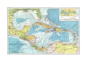
Central America, Cuba, Porto Rico, And The Islands Of The Caribbean Sea
Issue: February 1913
|
|
|
|
|
|
|
| Product Highlights |
| Central America, Cuba, Porto Rico, And The Islands Of The Caribbean Sea |
| Item#: X NGC 021913 |
This beautiful map of Central America and the Caribbean features ocean bathymetry and colorful county borders, including overlapping colors demonstrating boundaries in dispute. Published in February 1913 one year before the completion of the Panama Canal, this work contains an abundance of unique details including principal lighthouses, U.S. Consular representatives, steamship routes, and coaling stations. The 1913 Central America, Cuba, Porto Rico, and the Islands of the Caribbean Sea map features:
• Inset map of the Panama Canal with a cross-section showing the canal elevation
• Cities, towns, and capitals including country capitals, state capitals, and colonial capitals
• Steamship routes with distances in nautical miles and railroads, both operating and under construction
• Submarine telegraph lines and wireless telegraph stations
• Coaling stations, ruins, and principal lighthouses
• Ocean bathymetry
• U.S. Consular representatives
Coverage Area: Cuba, Porto Rico (Puerto Rico), Caribbean, Mexico, Central America, West Indies
|
|
 |
More Product Details
This map requires 7 business days to print and laminate prior to shipping.
Appearing in the February 1913 issue of the National Geographic Magazine, this Central America, Cuba, Porto Rico, And The Islands Of The Caribbean Sea map has been reproduced from its original cartography in order to bring to life a beautiful poster previously only seen in National Geographic Magazine. This reproduction holds true to the high standards that National Geographic Maps are known for.
Perfect for home, office or classroom, this map also makes a great gift. Map collectors will surely want to add this map to their library.
The Paper version is printed on high quaility semi-gloss paper, perfect for framing.
The Laminated version uses 3mm laminate on both sides for durability, is easy to clean and markable.
From the National Geographic Classic Maps collection, this reproduction is just one of hundreds of titles available here. These maps are Printed on Demand. Sizes are approximate and may vary due to the nature of the trimming and laminating processes.
|
|
Shipping Conditions
Maps.com ships to Dometic US only
 | This product can only be shipped to the Domestic U.S.A. (No APO's or PO Boxes) |  | This map requires 2 business days to print and laminate prior to shipping. |
|
|
|
|


 Click here to zoom!