 |
|
|
|
|
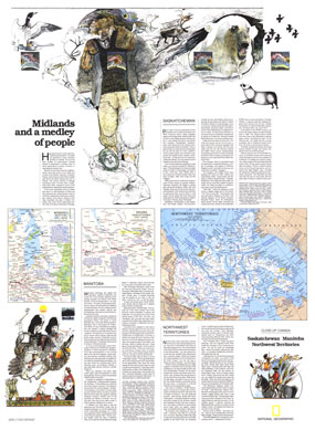
Saskatchewan And Manitoba Map 1979
Issue: May 1979
|
|
|
|
|
|
|
| Product Highlights |
| Saskatchewan And Manitoba Map 1979 |
| Item#: X NGC 051979b |
Published in May 1979 as half of a two-map set showcasing Canada's midland provinces, the "Saskatchewan, Manitoba, Northwest Territories: Midlands and a Medley of People" map provides a remarkable amount of tourist information about this diverse region. Whether it's fishing and canoeing in the region's countless lakes or attending festivals like Manitoba's Folklorama, these provinces have plenty of interesting activities to keep you busy. The 1979 Saskatchewan, Manitoba, Northwest Territories: Midlands and a Medley of People map features:
• An inset map of the Northwest Territories with notes on historic events and sites of interest
• Map of Regina with places of interest noted
• Map of Winnipeg with places of interest noted
• Articles on the three provinces which include an abundance of tourist information
• Colorful illustrations of people and wildlife
Coverage Area: Saskatchewan, Manitoba, Northwest Territories
|
|
 |
More Product Details
This map requires 7 business days to print and laminate prior to shipping.
Appearing in the May 1979 issue of the National Geographic Magazine, Saskatchewan, Manitoba, Northwest Territories: Midlands and a Medley of People map has been reproduced from its original cartography in order to bring to life a beautiful poster previously only seen in National Geographic Magazine. This reproduction holds true to the high standards that National Geographic Maps are known for.
Perfect for home, office or classroom, this map also makes a great gift. Map collectors will surely want to add this map to their library.
The Paper version is printed on high quaility semi-gloss paper, perfect for framing.
The Laminated version uses 3mm laminate on both sides for durability, is easy to clean and markable.
From the National Geographic Classic Maps collection, this reproduction is just one of hundreds of titles available here. These maps are Printed on Demand. Sizes are approximate and may vary due to the nature of the trimming and laminating processes.
|
|
Shipping Conditions
Maps.com ships to Dometic US only
 | This product can only be shipped to the Domestic U.S.A. (No APO's or PO Boxes) |  | This map requires 2 business days to print and laminate prior to shipping. |
|
|
|
|


 Click here to zoom!