 |
|
|
|
|
Countries Of The Caribbean Map 1947
Issue: October 1947
|
|
|
|
|
|
|
| Product Highlights |
| Countries Of The Caribbean Map 1947 |
| Item#: X NGC 101947 |
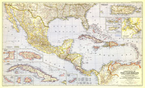
Published in October 1947, this map of the Countries of the Caribbean features Mexico, Central America, and the West Indies as well the islands of the Caribbean. Inset maps of ten of the most prominent islands and the Panama Canal zone provide detail of the region. The article "Guatemala Revisited" accompanied the map. The 1947 Countries of the Caribbean map features:
• Inset maps of the islands of Antigua, Bermuda Islands, Cuba, Exuma (Bahama Islands), Jamaica, Puerto Rico, St. Croix, St. Lucia, St. Thomas and St. John, and Trinidad
• Inset map of the Panama Canal Zone
• Country capitals, state capitals, cities, and towns
• Principal railways, roads, Pan-American highway, canals, and airports with scheduled transport service
• Ruins
• Elevations and depths in feet
Coverage Area: West Indies, Mexico, Central America, southern United States
|
|
 |
More Product Details
This map requires 7 business days to print and laminate prior to shipping.
Appearing in the October 1947 issue of the National Geographic Magazine, this Countries of the Caribbean, including Mexico, Central America and the West Indies map has been reproduced from its original cartography in order to bring to life a beautiful poster previously only seen in National Geographic Magazine. This reproduction holds true to the high standards that National Geographic Maps are known for.
Perfect for home, office or classroom, this map also makes a great gift. Map collectors will surely want to add this map to their library.
The Paper version is printed on high quaility semi-gloss paper, perfect for framing.
The Laminated version uses 3mm laminate on both sides for durability, is easy to clean and markable.
From the National Geographic Classic Maps collection, this reproduction is just one of hundreds of titles available here. These maps are Printed on Demand. Sizes are approximate and may vary due to the nature of the trimming and laminating processes.
|
|
Shipping Conditions
Maps.com ships to Dometic US only
 | This product can only be shipped to the Domestic U.S.A. (No APO's or PO Boxes) |  | This map requires 2 business days to print and laminate prior to shipping. |
|
|
|
|


 Click here to zoom!