 |
|
|
|
|
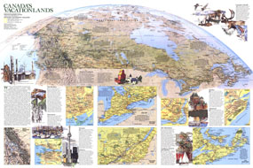
Canada Vacationlands Map 1985
Issue: November 1985
|
|
|
|
|
|
|
| Product Highlights |
| Canada Vacationlands Map 1985 |
| Item#: X NGC 111985b |
Explore Canadas diverse vacationlands with this educational map printed in November 1985 to supplement the political and physical map of the country and the article "Kluane: Canadas Icy Wilderness Park." From world-class wilderness to spirited cities, Canada has something for every vacationer. The 1985 Canada map features:
• National parks, provincial parks, and ski areas
• Inset maps of Quebec, the Maritimes, Montreal, Southern Ontario, Southern Quebec, Toronto, Vancouver, and Rocky Mountain Parks
• Interesting facts about each region and the major cities
• An abundance of place names including capitals, cities, and towns
• Highways, roads, trails, passenger railroads, scheduled air service, and canals
• Geographical features including mountains, rivers, and lakes
• Compelling illustrations
Coverage Area: Canada
|
|
 |
More Product Details
This map requires 7 business days to print and laminate prior to shipping.
Appearing in the November 1985 issue of the National Geographic Magazine, this Canada Vacationlands map has been reproduced from its original cartography in order to bring to life a beautiful poster previously only seen in National Geographic Magazine. This reproduction holds true to the high standards that National Geographic Maps are known for.
Perfect for home, office or classroom, this map also makes a great gift. Map collectors will surely want to add this map to their library.
The Paper version is printed on high quaility semi-gloss paper, perfect for framing.
The Laminated version uses 3mm laminate on both sides for durability, is easy to clean and markable.
From the National Geographic Classic Maps collection, this reproduction is just one of hundreds of titles available here. These maps are Printed on Demand. Sizes are approximate and may vary due to the nature of the trimming and laminating processes.
|
|
Shipping Conditions
Maps.com ships to Dometic US only
 | This product can only be shipped to the Domestic U.S.A. (No APO's or PO Boxes) |  | This map requires 2 business days to print and laminate prior to shipping. |
|
|
|
|


 Click here to zoom!