SHOP BY YEAR :: FOR OFFICE :: FOR CLASSROOM :: GIFT IDEAS :: CUSTOMER SERVICE

Where Did Columbus Discover America? Map 1986
Issue: November 1986
More Views
Enlarge Image
ZoomClick here to zoom!
Purchase Product :
Please select map format:
Laminated   
20.5" x 14.5" - $19.95
Laminated-w/Plastic Rails  (What are rails?)
20.5" x 14.5" - $29.95
Paper
20.5" x 14.5" - $14.95
Wallzilla Adhesive Format
20.5" x 14.5" - $34.95
Product Highlights
Where Did Columbus Discover America? Map 1986
Item#: X NGC 111986a

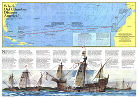
The site of Columbus's first landfall in the New World has been a controversial subject since his landing there in 1492. Watling Island, renamed San Salvador, has been the choice of many scholars, but a new theory presented by Luis and Ethel Marden who tracked the journey presented on this map points to Samana Cay. Published in National Geographic Magazine in November 1986 with the "Threading the Islands" map and three articles on Columbus, the "Where Did Columbus Discover America?" map presents a new answer to this centuries-old question.

The 1986 "Where Did Columbus Discover America?" map features:
• A map detailing Columbus's track as charted by Luis and Ethel Marden
• An article about the search for the place of Columbus's landing
• An explanation of the nautical symbols used
• An illustration of the Nina, Pinta, and Santa Maria sailing off to the New World

Coverage Area: Atlantic Ocean, Canary Islands, Bahamas

More Product Details

This map requires 7 business days to print and laminate prior to shipping.

Appearing in the November 1986 issue of the National Geographic Magazine, this Where Did Columbus Discover America? map has been reproduced from its original cartography in order to bring to life a beautiful poster previously only seen in National Geographic Magazine. This reproduction holds true to the high standards that National Geographic Maps are known for.

Perfect for home, office or classroom, this map also makes a great gift. Map collectors will surely want to add this map to their library.

The Paper version is printed on high quaility semi-gloss paper, perfect for framing.

The Laminated version uses 3mm laminate on both sides for durability, is easy to clean and markable.

From the National Geographic Classic Maps collection, this reproduction is just one of hundreds of titles available here. These maps are Printed on Demand. Sizes are approximate and may vary due to the nature of the trimming and laminating processes.
Shipping Conditions
Maps.com ships to Dometic US only

US FlagThis product can only be shipped to the Domestic U.S.A. (No APO's or PO Boxes)
TimeThis map requires 2 business days to print and laminate prior to shipping.