 |
|
|
|
|
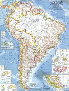
South America Map 1960
Issue: February 1960
|
|
|
|
|
|
|
| Product Highlights |
| South America Map 1960 |
| Item#: X NGC 021960 |
Published in February 1960 with the article "Chile, the Long and Narrow Land," map is the first of the South American maps to feature the many islands in the region. Thirteen inset maps detail the individual islands or island groups. The 1960 South America map features:
• Map of the Strait of Magellan
• Inset maps of Atol das Rocas, Easter Island, the Falkland Islands, Fernando de Noronha, the Galapagos Islands, Malpelo Island, the Martin Vaz Islands, Saint Peter and Saint Paul Rocks, Sala y Gomez, San Ambrosio and San Feliz Islands, Trinidade, and both Mas a Tierra Island and Mas Afuero Island (Juan Fernandez Islands)
• Ocean bathymetry and currents
• Geographical features including mountains, rivers, lakes, dry salt lakes, and glaciers
• Thousands of place names including capitals, cities, and towns
• Pan American Highway system, railroads, roads, and places with scheduled air service
• Oil fields and pipelines
Coverage Area: South America
|
|
 |
More Product Details
This map requires 7 business days to print and laminate prior to shipping.
Appearing in the February 1960 issue of the National Geographic Magazine, this South America map has been reproduced from its original cartography in order to bring to life a beautiful poster previously only seen in National Geographic Magazine. This reproduction holds true to the high standards that National Geographic Maps are known for.
Perfect for home, office or classroom, this map also makes a great gift. Map collectors will surely want to add this map to their library.
The Paper version is printed on high quaility semi-gloss paper, perfect for framing.
The Laminated version uses 3mm laminate on both sides for durability, is easy to clean and markable.
From the National Geographic Classic Maps collection, this reproduction is just one of hundreds of titles available here. These maps are Printed on Demand. Sizes are approximate and may vary due to the nature of the trimming and laminating processes.
|
|
Shipping Conditions
Maps.com ships to Dometic US only
 | This product can only be shipped to the Domestic U.S.A. (No APO's or PO Boxes) |  | This map requires 2 business days to print and laminate prior to shipping. |
|
|
|
|


 Click here to zoom!